
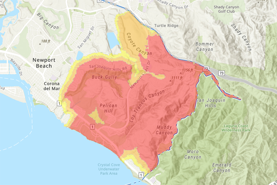
Updated Fire Hazard Severity Zone maps from the State of California are now available for public review and comment on the City of Newport Beach’s website.
Residents can view the updated maps and submit public comments at: www.newportbeachca.gov/firemaps.
The City received the updated Local Responsibility Area (LRA) Fire Hazard Severity Zone maps on Monday, March 24 and has made them available to the public on the City’s website. To enhance accessibility, The City has created webpage to view the new maps. This system provides multiple layers, enabling residents to compare the 2012 adopted maps with the newly updated maps.
The LRA Fire Hazard Severity Zone maps, developed by the California Department of Forestry and Fire Protection (CAL FIRE), identify areas at varying levels of fire hazard based on factors such as vegetation, topography, and weather patterns. These maps help guide fire prevention efforts and inform building and safety regulations in designated fire-prone areas. This is CAL FIRE’s first update for the Orange County area in 14 years.
“These updated maps represent an important step in understanding and mitigating fire hazards in Newport Beach,” said Fire Chief Jeff Boyles. “We encourage residents to review the maps, provide feedback, and participate in the upcoming public comment process.”
Following a 30-day public comment period, the updated maps will be brought before the Newport Beach City Council for formal adoption. This effort aligns with the California Building Standards Commission’s adoption of the California Wildland-Urban Interface Code, set to take effect on January 1, 2026. While the new code does not introduce major regulatory changes, it consolidates existing fire safety laws into a single, comprehensive resource for regulatory agencies, developers, and residents.
It is important to note that these maps assess fire hazard rather than fire risk. Fire hazard mapping is based on physical conditions that influence expected fire behavior over a 50-year period, without accounting for short-term modifications.
These Fire Hazard Severity Zone maps are distinct from the risk maps used by insurance companies. Risk maps evaluate the potential damage a fire could inflict under current conditions, incorporating factors such as home hardening and fuel reduction efforts.
However, property owners in the high and very-high zones must comply with new state building codes, landscaping requirements and real estate disclosure rules. Homes in very-high fire zones are now subject to “defensible space” requirements such as vegetation clearance, and modifications such as ember-resistant vents.