This post was originally published on this site
ANAHEIM, Calif. (March 15, 2022) — The City Council Tuesday officially adopted a final map for Anaheim’s updated council districts, following months of public input and discussion.
The City Council voted to introduce the ordinance adopting the final map on March 1 and completed a second reading on March 15. The new districts will go into effect after 30 days, on April 14.
Anaheim began the redistricting process in July 2021 and has hosted dozens of community meetings and public hearings in the past nine months. Anaheim residents also submitted suggested district maps and comments on map proposals via email and online at AnaheimRedistricting.org.
Ultimately, the council considered six focus maps submitted by the public and the city’s demographer. Following discussions and public comments Tuesday, the City Council selected the map numbered 114.
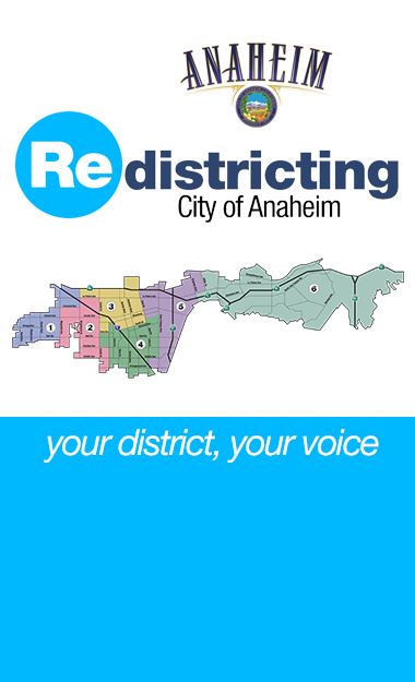
The new map implements changes to Districts 2, 3, 4, and 5 based on the 2020 Census and public input on communities of interest.
District 2 expands to the south below Cerritos Avenue and to the east to 9th Street to include the area around Stoddard Park.
District 3 expands to the west from Euclid Street to Brookhurst Street, encompassing the neighborhoods above La Palma Avenue around John Marshall Park.
District 4 expands to the east to include some of the newer Platinum Triangle apartment communities and to the north to include neighborhoods around Ross Park.
The new district map does not include any changes to District 1 or District 6.
You can view an interactive version of the map here.
Anaheim first adopted a district-based election system in 2016, with districts based on the 2010 Census. The city must complete a redistricting process every 10 years.
For more information, visit AnaheimRedistricting.org.
****
El Concejo Municipal adoptó un mapa final para los distritos del consejo actualizados de Anaheim el martes, después de meses de aportes y discusiones públicas.
El Concejo Municipal votó para introducir una ordenanza que adopta el mapa final el 1 de marzo y completó una segunda lectura el 15 de marzo. Los nuevos distritos entrarán en vigencia después de 30 días, el 14 de abril.
Anaheim comenzó el proceso de redistribución en julio de 2021 y ha organizado docenas de reuniones comunitarias y audiencias públicas en los últimos nueve meses. Los residentes de Anaheim también presentaron sugerencias de mapas del distrito y comentarios sobre las propuestas de mapas por correo electrónico y en línea en AnaheimRedistricting.org.
Al final, el consejo consideró seis mapas de enfoque, presentados por el público y el demógrafo de la ciudad. Después de discusiones y comentarios públicos el martes, el Concejo Municipal votó para adoptar el mapa numerado 114.
El mapa nuevo implementa cambios en los Distritos 2, 3, 4 y 5 según el Censo de 2020 y los aportes públicos sobre las comunidades de interés.
El Distrito 2 se expande hacia el sur debajo de Cerritos Avenue y hacia el este hasta 9th Street para incluir el área alrededor de Stoddard Park.
El Distrito 3 se expande hacia el oeste desde Euclid Street hasta Brookhurst Street, incluyendo los vecindarios sobre La Palma Avenue alrededor de John Marshall Park.
El Distrito 4 se expande hacia el este para incluir algunos de los nuevos complejos de apartamentos Platinum Triangle y hacia el norte para incluir vecindarios alrededor de Ross Park.
El mapa no incluye ningún cambio en el Distrito 1 o el Distrito 6.
Puedes ver una versión interactiva del mapa aquí.
Anaheim adoptó por primera vez un sistema electoral basado en el distrito en 2016, con distritos basados en el Censo de 2010. La ciudad debe completar un proceso de redistritación cada 10 años.
Para obtener más información, visite AnaheimRedistricting.org.